


Services
GIS at UWF turns geographic data into visuals—maps, graphs, and more—to help partners solve problems and make informed decisions.
GIS Services
Our research and services fall under 5 main areas: Planning support, Image and data processing, Web mapping, Map Design/Production, and Specialized Training Development. GIS services can be procured hourly for short projects and map design or longer staff time-buyouts for lengthy research projects. The fees collected allow us to devote time to sponsored research while improving our services.
- Map design and production
- Spatial Analysis / GeoStatistics
- Address Matching / Geocoding
- GPS Mapping and Data Collection
- GIS Project Development and Management
- Geo-Database Design
- Web Mapping Development
The GIS Lab
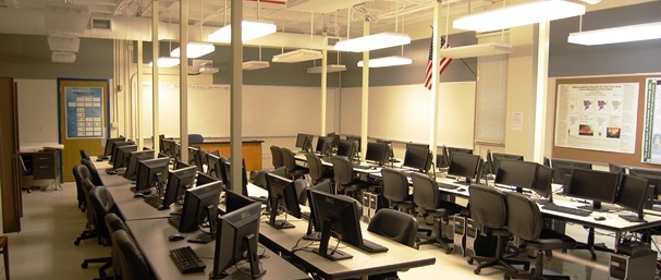
GIS at UWF maintains a state-of-the-art GeoSpatial laboratory on the UWF Pensacola campus. The multi-use facility is designed to accommodate class instruction, training courses, and research endeavors. This facility is located on the third floor of Building 13 (room 311). The laboratory is open for students to work on GIS coursework or geospatial-related projects during business hours when classes are not being held. See the Current Lab schedule for details regarding open lab hours.
Students using UWF GIS facilities for faculty research or assisting with GIS courses may be granted an entrance code for after-hours access to lab facilities with a written request from their faculty advisor or supervisory professor. Here is a complete list of GIS Lab software titles available on each lab computer.
The Lab can also be rented by community partners to hold GIS-related training.
GIS at UWF maintains equipment for and expertise in collecting spatially accurate, high-quality data in the field including GPS and surveying instruments. Careful planning and the right tools are essential to any field-based study.
GIS at UWF provides licenses and support for ESRI ArcGIS and other GeoSpatial software packages.
Finding the right data is key to a successful project. UWF GIS staff can help you find the most relevant and accurate data sources for your research or other GIS projects.


