


Campus Map Wayfinding
The UWF campus map features a wayfinding tool for navigating between locations on the Pensacola campus as well as at UWF Emerald Coast in Fort Walton Beach and UWF Historic Trust in Historic Pensacola. Wayfinding will provide users with an efficient route to navigate UWF including accessible routes.
How to Use Wayfinding
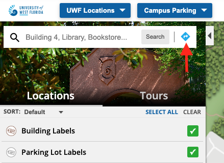
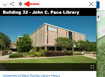
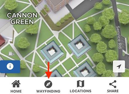
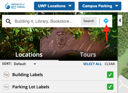
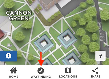
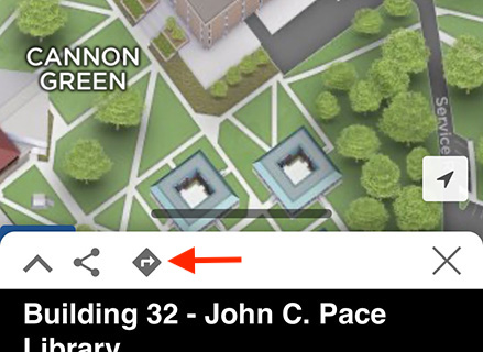
1.) Click the wayfinding button in the search bar on the UWF campus map or for an individual location marker (John C. Pace Library for example) to open the wayfinding tool. Please note that locations on the map with a polygon shape overlay indicates construction is in progress at that location. Click one of the four screenshots below to expand and scroll through the gallery for assistance finding the wayfinding button on desktop and mobile.


2.) Type to find and select the desired starting UWF location in the search field next to the A pinpoint icon that states search for a route starting point. Alternative options include selecting Use My Location (browser or device location permission may be required) or selecting Drop Map Pins to add two pins on the map.
- The Use My Location option may not provide an accurate user location on the map. Utilizing the location search field is the recommended option for location accuracy.
- The Drop Map Pins option will allow users to move the pins to specific locations on the map to create the wayfinding route. The A pinpoint icon is the starting location and the B pinpoint icon is the ending location.
3.) Follow the same instructions in the previous step for the desired ending UWF location in the search field next to the B pinpoint icon that states search for a route destination.
- Users may click the arrow swap icon (up and down arrows icon) to swap the entered starting and ending locations.
- Users may also click Clear to reset the location search fields.
4.) Click the Get Directions button to generate the wayfinding route on the campus then follow the path line and instructions to get to your desired UWF destination! Once your path line has been created, you will see the distance and estimated time to get to your destination.
- Click Options under the location search fields to switch between Feet / Miles and Kilometers / Meters for the Distance Units. The Feet / Miles option is selected by default.
5.) Users may click the show only accessible routes checkbox to display an accessible route between the UWF locations entered in the previous steps.
- If a user is provided with a non-accessible route when utilizing the show only accessible routes checkbox option, please contact Institutional Communications at brand@uwf.edu. Please provide the two UWF locations used with the wayfinding tool and the specific accessible route issue location.
- Additional accessibility resources are marked on the map for the Pensacola campus and UWF Emerald Coast. For additional assistance, UWF students may contact Student Accessibility Resources. UWF faculty and staff as well as the general public may contact the ADA Programs Office for assistance.
Institutional Communications welcomes feedback on the campus map and wayfinding tool. Please send feedback and questions to brand@uwf.edu.